Having Jegersberg everyday around me, I decided a few weeks ago that I would like to do a hike through Jegersberg all the way to Venessla and return through Barneheia. Some more people liked the idea of starting walking right in front of our flat and in the end, it was two of who wanted to do this trip. We agreed to stay out for 2 nights, sleeping in a hammock (with tarp, depending on the weather) and to bring all the food we needed, so to not go shopping in Venessla. For watersupply we wanted to use streams and brought enough gas to boil it, for navigation we would use map and compass.
We were free one weekend and the weatherforcast was good too, so spontaneously, we decided to go for it. The packing and foodpreperation went fast, since we had the whole semester to learn it and to get better at it.
Just before the start of our trip, both of us needed some more time to organize our lifes back home, so we delayed the departure from morning to afternoon. Since we were independent from transportation and free in the choices where we could sleep that night plus it was a holidaytrip and not „must do“, we were both fine with it.
A few hours later, we were good to go. With map and compass, we started our trip. Beforehand, we had printed out a map from Kartverkert.no/ norgeskart.no and made a rough plan where we would go. We did not mark a defined route but decided rather spontaneous which route to take, as long as it would lead us in the average direction of our daily destionation.
While walking, I realized fast that a marked route helps a lot for orientation: If you mark a route, you got an idea where to go and it helps you orientating on the map, finding the spots where you locate(d) yourself (last) and the tracks you follow more easily. It was not a big problem but would have made the orientation on the map easier. For the first few hours, we knew most of the times exactly where we were. At some point, my travelbuddy took the lead with the map and the other one followed. Not double checking every junction we came to helped us moving faster, but also made us take longer routes from time to time, when the leader misread the map. We ended up walking many highmeters up and down instead following a smooth upward track, headed through land with many ticks and less well maintained tracks and ended up in the middle of a forest, where we should have been close to water. The difficulties we were facing were the trails that were in the forest but not on the map at all. To check the direction we had to walk, we used a compass. We could circle an area in a radius of 500 meters, knowing we would be within that circle. Having checked the right direction, we started reading all kinds of nature signs: Hilltops, rivers and direction and elevation of the track. We decided to keep following the trail until we would find some more unique area and 10 Minutes later, we stood on the spot we wanted to be. Using the compass for a crossbearing was impossible in that moment, since our view was covered by forest and it was hard to see anything through the forest.
This experience was very helpfull for understanding navigation and orientation even better. Doing the navigation on other trips, I always had a teacher or very motivated classmates around me, that took over the lead and therefore, I never faced a situation where I actually got lost. We automatically started reading the little sign we often just talked about in class and it was satisfying to see, how well the orientation on rivers and hilltops worked out.
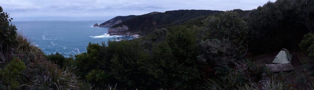
After a few hours of hiking, we decided to take a break, in which we got bitten by an incredible number of mosquitos. Our plan was to sleep close to a lake that night. Knowing that we did not have a tent or mosquitorepellent with us, we questioned our plan. On top of this, the both of us felt tired and I got blisters on my feet. The upcoming question was if we would enjoy going further or if we should head back. Since we started pretty late, we just had 1.5 hours of sunlight left and decided, to head back and sleep at the inverted boat. The hike back was an easier route, less up and down and a very pretty track. While hiking, I realized that a remote route is not always the best one, once cause viewpoints are covered by forest and also for ticks and finding the right track (a big track is easier to follow than a very narrow one, crossing other narrow ones). We followed big tracks and used the map and maps.me for navigation, to be double sure not to get lost but reach our sleepingspot before sunlight would be gone. It was already late in the day and we could feel our bodys getting tired, we slipped a few times and moved slower than usually. After what felt a lot longer than one hour, we got to our sleepingspot, hang up the hammocks and prepared a hot drink. Since we have been walking all day through backcountry forest, we checked each other for ticks, found many, removed them and finally went to bed. During the trips in cold conditions, we did not have to think about insects at all, but now that the summer aproached we got surprised by the amount of those. Especially since the winter was a cold winter, i did not expect many ticks and mosquitos, but learned better. The next morning, we packed our packs again and walked the last few kilometers back home, enjoyed the sun and were happy about heading back. We could have hiked the original plan in those 3 days, but it would have been a challenge and we did not feel good enough to master it.
Regarding Teamwork, the two of us knew each other and chose to travel together, which made the working together more easily. Also, making decisions with just two people is easier than to make a decision based on the preferences of 7 people.
Summarized, I used the skills we learned this semester for this trip and enjoyed being able to start a trip so spontaneously and navigate in the forest, but also to experience how easy it is on the other hand to get lost. Further, not having preplanned a trail was ok, but made the navigation more difficult. Especially checking highmeters beforehand would have saved us hiking those and finding the better, less remote and more scenery trails. Eventually, we would have gotten further. Starting in the afternoon and not in the morning was also fine, but we still were awake the whole day. I realized, my body gets tired at a certain time and the later it is in the day, the more tiered I get. And once again, I learned how important a trip preperation is and especially, bringing the right equipment, such as mosquito and tick repellant.